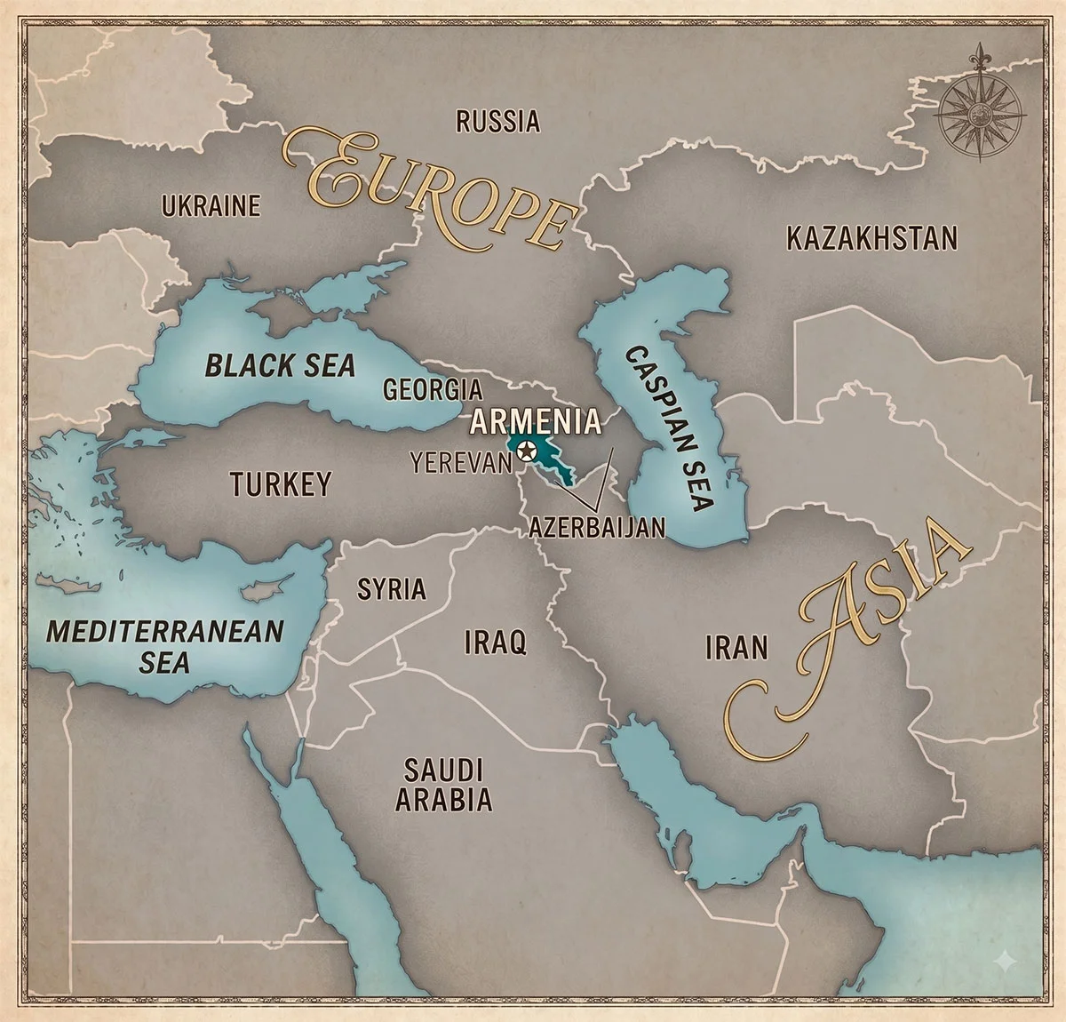
Pull up a map and find the spot where the Black Sea and the Caspian Sea almost pinch together, with Russia above and Iran below. That mountainous bridge of land is the Caucasus, and Armenia sits on its southern side. Small, landlocked, ancient, and wedged between four very different neighbors.
The exact location
Armenia occupies 29,743 square kilometers in the South Caucasus, at roughly 40 degrees north and 45 degrees east, about the latitude of Naples or Philadelphia. For scale, that’s Belgium, or Maryland. It was the smallest of the fifteen Soviet republics, and among its neighbors it’s a dwarf: Turkey is 26 times larger.
Its four borders tell most of modern Armenian history:
Turkey to the west (border closed since 1993). Georgia to the north (open, and Armenia’s main road to the outside world). Azerbaijan to the east (closed, a legacy of the Karabakh conflict). Iran to the south (open, just 44 kilometers of frontier, and economically vital). There’s also a fifth line on the map: Nakhchivan, an Azerbaijani exclave, touches Armenia’s southwest.
Two closed borders out of four is the geographic fact that shapes everything else about the country, from trade routes to politics.
Is Armenia in Europe or Asia?
Strictly by physical geography, Armenia is in West Asia. The most common continental divide runs along the Caucasus mountain watershed, and Armenia lies south of it, on the Armenian Highlands that spill into eastern Turkey and northwestern Iran.
Politically and culturally, the answer flips. Armenia is a member of the Council of Europe, plays in UEFA football competitions, sings in Eurovision, and adopted Christianity in 301 AD, before any country in Europe proper. In 2025 its parliament passed a law launching a bid for European Union membership. Geographers put it in Asia, institutions treat it as European, and Armenians mostly shrug and say both. We dig into the tug-of-war in is Armenia in Europe or Asia.
Is Armenia in the Middle East?
By convention, no. Armenia is grouped with Georgia and Azerbaijan as the South Caucasus, a region of its own. But the Middle East starts at the southern border: Iran is a neighbor, Turkey is a neighbor, and Syria and Iraq are a day’s drive beyond. Armenian communities have lived in Aleppo, Beirut, Tehran and Jerusalem for centuries, so the cultural entanglement with the Middle East runs deep even though the atlas keeps Armenia just outside it. That nearness is also why people ask whether Armenians are white or Middle Eastern, and the honest answer starts with this map.
What does the country actually look like?
Mountains, then more mountains. Armenia’s average elevation is around 1,800 meters, one of the highest of any country. The capital, Yerevan, sits in a valley at about 1,000 meters, staring across the closed Turkish border at Mount Ararat, the 5,137-meter volcano that is Armenia’s national symbol and, painfully, no longer on Armenian soil. In the east, Lake Sevan fills a bowl at 1,900 meters, one of the largest alpine lakes on Earth and the closest thing a landlocked nation has to a sea.
How do you get there?
Fly, realistically. Yerevan’s Zvartnots airport connects through hubs like Dubai, Doha, Vienna, Paris and Moscow, with most of Europe 3 to 5 hours away. Overland, the practical routes run north through Georgia (Tbilisi is a 5 to 6 hour drive) or south from Iran. And once you land, remember the clock: the whole country runs on a single time zone, four hours ahead of London, covered in what time is it in Armenia.